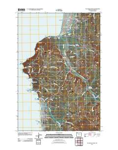
2011 Map of Tillamook Head
USGS Topo · Published 2011About this map
Seaside and Cannon Beach anchor this coastal survey, documenting the developed beachfronts and the dramatic geological interface of the northern Oregon shore. The landscape is defined by the massive headland of Tillamook Head, where Clark's Mountain and Rippet Mountain rise sharply from the Pacific. Between the towns, Ecola State Park and the Feldenheimer Forest Preserve protect significant stretches of coastal forest and shoreline, including iconic sea stacks like Haystack Rock, The Needles, and Sea Lion Rock Arch.
Find a feature on this map
71 named features on this map. Tap any name to fly to it.
Don’t see what you’re looking for? This feature index may not catch every label — zoom into the map to look around manually.
Map Details
Editions of this 2011 Tillamook Head Map
This is the sole edition of this map. No revisions or reprints were ever made.
Other maps of this area

1919 · Astoria
USGS Topo · 1:62,500

1939 · Astoria
USGS Topo · 1:62,500

1940 · Cape Falcon
USGS Topo · 1:62,500

1943 · Copalis Beach
USGS Topo · 1:250,000

1948 · Vancouver
USGS Topo · 1:250,000

1949 · Tillamook Head
USGS Topo · 1:24,000

1949 · Gearhart
USGS Topo · 1:24,000
1949 · Olney
USGS Topo · 1:24,000

1950 · Vancouver
USGS Topo · 1:250,000

1950 · Vancouver
USGS Topo · 1:250,000