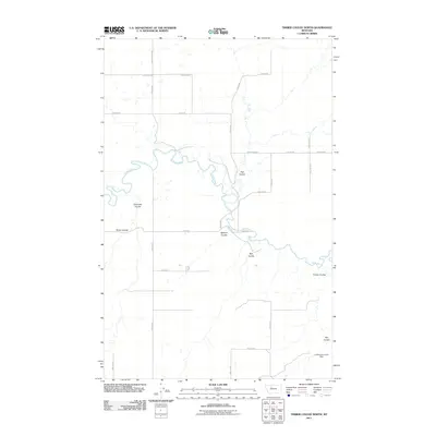
2011 Map of Timber Coulee North
USGS Topo · Published 2011About this map
Teton River meanders across this rural Montana landscape, its winding course defining the geography of Teton County. The terrain is deeply etched by numerous drainages, most notably Timber Coulee, Rye Coulee, and Flat Coulee, which channel runoff toward the river valley. This 2011 survey by the U.S. Geological Survey illustrates a modern agricultural and ranching grid system, where long stretches of road like Faris School Rd and Copenhauer follow section lines across the high plains. A localized water management point, the Lumberjack Junior Dam, is located in the southeastern corner of the quadrangle, highlighting the essential role of water storage in this arid environment. The map provides a detailed view of the infrastructure supporting this sparsely populated area, including the intersection of Collins Rd and north-south connectors like 24th Ln NE.
Find a feature on this map
24 named features on this map. Tap any name to fly to it.
Don’t see what you’re looking for? This feature index may not catch every label — zoom into the map to look around manually.
Map Details
Editions of this 2011 Timber Coulee North Map
This is the sole edition of this map. No revisions or reprints were ever made.
Other maps of this area

1886 · Great Falls
USGS Topo · 1:250,000

1920 · Conrad
USGS Topo · 1:125,000

1949 · Timber Coulee
USGS Topo · 1:62,500

1950 · Timber Coulee
USGS Topo · 1:62,500

1950 · Dutton
USGS Topo · 1:62,500

1954 · Great Falls
USGS Topo · 1:250,000

1954 · Shelby
USGS Topo · 1:250,000

1957 · Great Falls
USGS Topo · 1:250,000

1958 · Shelby
USGS Topo · 1:250,000
1965 · Sheep Coulee Spring
USGS Topo · 1:24,000