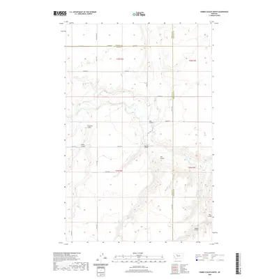
2020 Map of Timber Coulee North
USGS Topo · Published 2020About this map
The Teton River carves a winding path through this northern Montana landscape, where the high plains are deeply incised by a network of drainage features. This 2020 survey captures the convergence of Teton, Pondera, and Chouteau counties, a rural expanse defined more by its landforms than by modern development. The names etched across the terrain—such as Kinnerely Coulee, Kinley Coulee, and Spencer Coulee—speak to the importance of natural hydrology in an area dominated by large-scale agriculture and open range. A sparse but deliberate grid of roads, including Faris School Rd and 26th Rd NE, follows the township and range lines, providing access to the remote sections of T26N and T25N. The namesake Timber Coulee in the southeast corner further illustrates the character of this territory, where small breaks in the plateau offer shelter and varied topography amidst the sweeping northern plains.
Find a feature on this map
25 named features on this map. Tap any name to fly to it.
Don’t see what you’re looking for? This feature index may not catch every label — zoom into the map to look around manually.
Map Details
Editions of this 2020 Timber Coulee North Map
This is the sole edition of this map. No revisions or reprints were ever made.
Other maps of this area

1886 · Great Falls
USGS Topo · 1:250,000

1920 · Conrad
USGS Topo · 1:125,000

1949 · Timber Coulee
USGS Topo · 1:62,500

1950 · Timber Coulee
USGS Topo · 1:62,500

1950 · Dutton
USGS Topo · 1:62,500

1954 · Great Falls
USGS Topo · 1:250,000

1954 · Shelby
USGS Topo · 1:250,000

1957 · Great Falls
USGS Topo · 1:250,000

1958 · Shelby
USGS Topo · 1:250,000
1965 · Sheep Coulee Spring
USGS Topo · 1:24,000