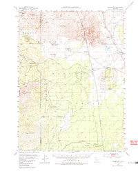
1952 Map of Timber Mountain
USGS Topo · Published 1985About this map
Lava Beds National Monument dominates the northern landscape of this survey, revealing a complex volcanic terrain marked by features like the Glass Flow and numerous volcanic cones including Caldwell Butte and Cougar Butte. The map captures a critical intersection of Modoc County's history, preserving the site of the Battle of Dry Lake 1873 during the Modoc War. This mid-century view illustrates a region defined by its timber and rail resources, where the Lumber RR and Southern Pacific corridors converge near settlements like Tionesta and Perez.
Find a feature on this map
35 named features on this map. Tap any name to fly to it.
Don’t see what you’re looking for? This feature index may not catch every label — zoom into the map to look around manually.
Map Details
Editions of this 1952 Timber Mountain Map
5 editions found
Other maps of this area

1886 · Modoc Lava Bed
USGS Topo · 1:250,000

1892 · Modoc Lava-Bed
USGS Topo · 1:250,000

1932 · Bartle
USGS Topo · 1:96,000

1939 · Bartle
USGS Topo · 1:125,000

1950 · Mt. Dome
USGS Topo · 1:62,500

1951 · Clear Lake Reservoir
USGS Topo · 1:62,500

1951 · Tulelake
USGS Topo · 1:62,500

1952 · Timber Mountain
USGS Topo · 1:62,500

1952 · Hackamore
USGS Topo · 1:62,500

1952 · Medicine Lake
USGS Topo · 1:62,500