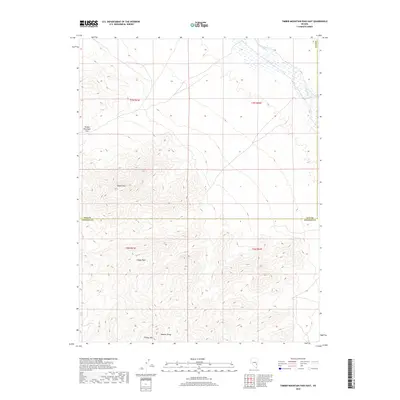
2018 Map of Timber Mountain Pass East
USGS Topo · Published 2018About this map
Seaman Range dominates the southern half of this Nevada landscape, where the high elevation of Indian Peak and Timber Mtn rises above the arid valley floor. The map documents the high-desert terrain where Nye County meets Lincoln County in a series of dramatic volcanic and sedimentary ridges. The northeastern corner of the quadrangle is defined by the ephemeral path of the White River, while the western edge is marked by the steep elevation change at Black Cliff. This area, surveyed by the U.S. Geological Survey in 2018, illustrates a remote segment of the Great Basin where topographic landmarks like Timber Mountain Pass served as critical navigation points for traverse through the basin-and-range province.
Find a feature on this map
12 named features on this map. Tap any name to fly to it.
Don’t see what you’re looking for? This feature index may not catch every label — zoom into the map to look around manually.
Map Details
Editions of this 2018 Timber Mountain Pass East Map
This is the sole edition of this map. No revisions or reprints were ever made.
Other maps of this area
1885 · Pioche
USGS Topo · 1:250,000
1886 · Pioche
USGS Topo · 1:250,000

1954 · Caliente
USGS Topo · 1:250,000

1956 · Lund
USGS Topo · 1:250,000
1959 · Caliente
USGS Topo · 1:250,000

1960 · Lund
USGS Topo · 1:250,000
1970 · Oreana Spring
USGS Topo · 1:24,000
1970 · Deadman Spring
USGS Topo · 1:24,000
1970 · Weepah Spring
USGS Topo · 1:24,000
1971 · Silver King Mtn SW
USGS Topo · 1:24,000