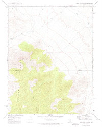
1971 Map of Timber Mtn Pass East
USGS Topo · Published 1973About this map
Timber Mountain dominates this portion of the Seaman Range as it appeared in the early 1970s. The landscape is defined by the high elevations of the range and the lower drainage of the White River in the northeast. This 1971 field check captures a network of Jeep Trails navigating the desert terrain, illustrating how this remote area was accessed for exploration and mining. Evidence of mineral exploration is found near the southern edge of the sheet, where small-scale Prospects are recorded. The map also delineates the high-desert border between Nye Co and Lincoln Co, crossing the central peaks. Notable landmarks like Black Cliff and the Timber Mountain Pass provide critical orientation points in an area otherwise characterized by its isolated high-country topography.
Find a feature on this map
8 named features on this map. Tap any name to fly to it.
Don’t see what you’re looking for? This feature index may not catch every label — zoom into the map to look around manually.
Map Details
Editions of this 1971 Timber Mtn Pass East Map
This is the sole edition of this map. No revisions or reprints were ever made.
Other maps of this area

1885 · Pioche
USGS Topo · 1:250,000

1886 · Pioche
USGS Topo · 1:250,000

1954 · Caliente
USGS Topo · 1:250,000

1956 · Lund
USGS Topo · 1:250,000

1959 · Caliente
USGS Topo · 1:250,000

1960 · Lund
USGS Topo · 1:250,000

1970 · Oreana Spring
USGS Topo · 1:24,000
1970 · Deadman Spring
USGS Topo · 1:24,000
1970 · Weepah Spring
USGS Topo · 1:24,000
1971 · Silver King Mtn SW
USGS Topo · 1:24,000