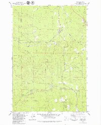
1979 Map of Timber
USGS Topo · Published 1979About this map
The Southern Pacific railroad line winds through the heart of the Tillamook State Forest in this late 1970s survey of northwestern Oregon. The small settlements of Timber and Westimber serve as focal points along the Nehalem River, while the southern reaches of the map are defined by the headwaters of Gales Creek. The terrain is characterized by prominent heights like Round Top and Burgholzer Ridge, as well as infrastructure essential to the timber industry, including several borrow pits and specialized roads like Bell Camp Road.
Find a feature on this map
47 named features on this map. Tap any name to fly to it.
Don’t see what you’re looking for? This feature index may not catch every label — zoom into the map to look around manually.
Map Details
Editions of this 1979 Timber Map
2 editions found
Other maps of this area

1940 · Vernonia
USGS Topo · 1:62,500

1941 · Keasey
USGS Topo · 1:62,500

1941 · Timber
USGS Topo · 1:62,500

1941 · Gales Creek
USGS Topo · 1:62,500

1943 · Vernonia
USGS Topo · 1:62,500

1943 · Keasey
USGS Topo · 1:62,500

1948 · Vancouver
USGS Topo · 1:250,000

1950 · Vancouver
USGS Topo · 1:250,000

1950 · Vancouver
USGS Topo · 1:250,000

1955 · Timber
USGS Topo · 1:62,500