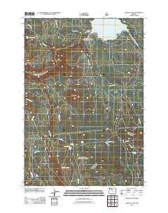
2011 Map of Timothy Lake
USGS Topo · Published 2011About this map
Timothy Lake serves as the focal point of this high-elevation landscape in the Mt. Hood National Forest, formed by the Timothy Lake Dam at the head of the Oak Grove Fork Clackamas River. This 2011 survey illustrates the intricate drainage network of the Clackamas watershed, where numerous creeks such as Anvil Creek, Stone Creek, and Cabin Creek descend from the high ridges. The map captures a landscape defined by significant timber and recreation infrastructure, including the winding Peavine Rd which provides access to the higher elevations of Peavine Mountain. For those researching local geography, the map identifies several smaller water bodies like Buck Lake and Summit Lake, alongside a concentration of named water sources such as Peavine Spring, Sheep Spring, and Dry Creek Spring, highlighting the essential hydrology of this Cascades environment.
Find a feature on this map
22 named features on this map. Tap any name to fly to it.
Don’t see what you’re looking for? This feature index may not catch every label — zoom into the map to look around manually.
Map Details
Editions of this 2011 Timothy Lake Map
This is the sole edition of this map. No revisions or reprints were ever made.
Other maps of this area

1924 · Mount Hood
USGS Topo · 1:125,000

1927 · Mount Hood
USGS Topo · 1:125,000

1927 · Mt. Jefferson
USGS Topo · 1:125,000

1930 · Mt. Jefferson
USGS Topo · 1:125,000

1953 · The Dalles
USGS Topo · 1:250,000

1955 · Bend
USGS Topo · 1:250,000

1956 · The Dalles
USGS Topo · 1:250,000

1956 · High Rock
USGS Topo · 1:62,500

1956 · Mt. Wilson
USGS Topo · 1:62,500

1957 · Bend
USGS Topo · 1:250,000