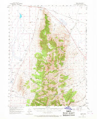
1955 Map of Timpie
USGS Topo · Published 1967About this map
The Stansbury Mountains dominate this mid-century survey of Tooele County, with the rugged peaks rising sharply between the alkali flats of Skull Valley and the western edge of Grantsville. This 1955 landscape is defined by the high-elevation slopes of the Wasatch National Forest and a string of mining claims including the Monte Carlo Mine, Utah Bunker Hill Mine, and Monarch Mine. The corridor along the northern tip of the range is a vital transit artery, featuring the Western Pacific railroad and the remote outpost at Timpie. Local water sources were essential for survival in this arid terrain, as evidenced by the numerous named catchments like Horseshoe Springs, Big Spring, and Chokecherry Spring. The map also traces the era's ranching footprint at Delle Ranch and Deseret Ranch, providing a clear record of the region's mid-century pastoral and industrial geography.
Find a feature on this map
71 named features on this map. Tap any name to fly to it.
Don’t see what you’re looking for? This feature index may not catch every label — zoom into the map to look around manually.
Map Details
Editions of this 1955 Timpie Map
2 editions found
Other maps of this area

1885 · Tooele Valley
USGS Topo · 1:250,000

1918 · Stockton
USGS Topo · 1:62,500

1953 · Tooele
USGS Topo · 1:250,000

1955 · Timpie
USGS Topo · 1:62,500

1955 · Deseret Peak
USGS Topo · 1:62,500

1955 · Burmester
USGS Topo · 1:24,000

1955 · Grantsville
USGS Topo · 1:24,000

1955 · Stockton
USGS Topo · 1:62,500

1955 · Tooele
USGS Topo · 1:250,000

1968 · Poverty Point
USGS Topo · 1:24,000