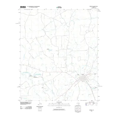
2010 Map of Timpson
USGS Topo · Published 2010About this map
The town of Timpson serves as the primary hub on this map, situated amidst a dense network of country roads and timberland in East Texas. The landscape is defined by the winding course of the Attoyac River and numerous tributaries such as Hardage Creek, Byfield Creek, and Flat Fork Creek. Local genealogy and land-use history are well-represented by the inclusion of the Woodlawn Cemetery and the more remote Dixon Cemetery. The era's focus on water management and conservation is evident through several major projects, including the Soil Conservation Service Site 7 Reservoir and the Soil Conservation Service Site 8 Reservoir. Small private water bodies like Hudman Lake and Julian Lake dot the countryside, illustrating the transition from traditional agriculture to managed reservoirs and recreational lakes during the late 20th and early 21st centuries.
Find a feature on this map
70 named features on this map. Tap any name to fly to it.
Don’t see what you’re looking for? This feature index may not catch every label — zoom into the map to look around manually.
Map Details
Editions of this 2010 Timpson Map
This is the sole edition of this map. No revisions or reprints were ever made.
Other maps of this area

1953 · Palestine
USGS Topo · 1:250,000

1956 · Tyler
USGS Topo · 1:250,000

1957 · Palestine
USGS Topo · 1:250,000

1958 · Timpson
USGS Topo · 1:62,500

1958 · Carthage
USGS Topo · 1:62,500

1960 · Minden
USGS Topo · 1:62,500

1960 · Mount Enterprise
USGS Topo · 1:62,500

1983 · Long Branch
USGS Topo · 1:24,000
1983 · Gary
USGS Topo · 1:24,000
1983 · Lake Murvaul
USGS Topo · 1:24,000