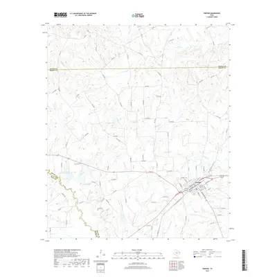
2019 Map of Timpson
USGS Topo · Published 2019About this map
Timpson serves as the central hub of this East Texas landscape, where the street grid aligns with the historic transit corridor of N Railroad Ave and Railroad Ave. The town's layout, featuring names like Austin St, Garrison St, and Bear Dr, reflects a established community structure at the intersection of local commerce and regional travel. Beyond the town limits, the terrain is defined by a dense network of watercourses, including Flat Fork Cr, Byfield Cr, and Brushy Cr, which drain the timbered uplands near the Panola and Rusk county lines.
Find a feature on this map
96 named features on this map. Tap any name to fly to it.
Don’t see what you’re looking for? This feature index may not catch every label — zoom into the map to look around manually.
Map Details
Editions of this 2019 Timpson Map
This is the sole edition of this map. No revisions or reprints were ever made.
Other maps of this area

1953 · Palestine
USGS Topo · 1:250,000

1956 · Tyler
USGS Topo · 1:250,000

1957 · Palestine
USGS Topo · 1:250,000

1958 · Timpson
USGS Topo · 1:62,500

1958 · Carthage
USGS Topo · 1:62,500

1960 · Minden
USGS Topo · 1:62,500

1960 · Mount Enterprise
USGS Topo · 1:62,500

1983 · Long Branch
USGS Topo · 1:24,000
1983 · Gary
USGS Topo · 1:24,000
1983 · Lake Murvaul
USGS Topo · 1:24,000