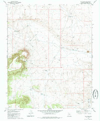
1980 Map of Tin House
USGS Topo · Published 1985About this map
Long Point defines the western reaches of this high-desert landscape in Coconino County, where the topography drops sharply from a plateau into a complex network of draws and washes. This 1970s field-checked environment is defined by its sparse water infrastructure, essential for ranching and survival in the arid Arizona interior. Named water sources such as Long Point Well, Cajon Tank, and Paul Moore Tank are scattered across the terrain, illustrating the critical role of water management in this region.
Find a feature on this map
18 named features on this map. Tap any name to fly to it.
Don’t see what you’re looking for? This feature index may not catch every label — zoom into the map to look around manually.
Map Details
Editions of this 1980 Tin House Map
2 editions found
Other maps of this area

1886 · Chino
USGS Topo · 1:250,000

1891 · Chino
USGS Topo · 1:250,000

1948 · Williams
USGS Topo · 1:250,000

1954 · Williams
USGS Topo · 1:250,000

1956 · Williams
USGS Topo · 1:250,000

1960 · Williams
USGS Topo · 1:250,000

1961 · Williams
USGS Topo · 1:250,000

1979 · Little Harpo Canyon
USGS Topo · 1:24,000

1980 · Hazen Hole Tank
USGS Topo · 1:24,000
1980 · Markham Dam
USGS Topo · 1:24,000