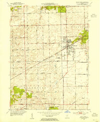
1953 Map of Tinley Park
USGS Topo · Published 1955About this map
Tinley Park and Orland Park anchor this 1950s landscape where the agricultural roots of the Cook and Will County border begin to meet suburban expansion. The Chicago Rock Island and Pacific railroad bisects the terrain, supporting the growth of Goeselville and Oak Forest near the St Mihiel Reservation. Genealogists will find several burial grounds mapped, including Orland Park Cem, Hickory Cem, and Frankfort Cem, while the location of local education is preserved through rural schools like Sedan Prairie Sch and Gatchell Sch.
Find a feature on this map
46 named features on this map. Tap any name to fly to it.
Don’t see what you’re looking for? This feature index may not catch every label — zoom into the map to look around manually.
Map Details
Editions of this 1953 Tinley Park Map
This is the sole edition of this map. No revisions or reprints were ever made.
Other maps of this area

1890 · Des Plaines
USGS Topo · 1:62,500

1892 · Calumet
USGS Topo · 1:62,500

1893 · Calumet
USGS Topo · 1:62,500

1894 · Des Plaines
USGS Topo · 1:62,500

1900 · Des Plaines
USGS Topo · 1:62,500

1900 · Calumet
USGS Topo · 1:62,500

1901 · Calumet
USGS Topo · 1:62,500

1901 · Des Plaines
USGS Topo · 1:62,500

1928 · Palos Park
USGS Topo · 1:24,000

1928 · Sag Bridge
USGS Topo · 1:24,000