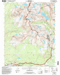
1994 Map of Tioga Pass
USGS Topo · Published 1997About this map
Tuolumne River headwaters and the high alpine terrain of the Sierra Nevada define this mid-1990s survey. The landscape is a complex intersection of protected lands, including Yosemite National Park, the Yosemite Wilderness, and the Inyo National Forest. High-altitude research and history are visible at the Carnegie Institute Experimental Station and the Parsons Memorial Lodge near Soda Springs. The map documents the legacy of high-country mining, notably at Bennettville and the Great Sierra Mine, while the Hess Mine sits further north near Lundy Lake. Glacial features such as the Conness Glacier and dramatic granite formations like Lambert Dome and Puppy Dome dominate the topography. Modern recreation is centered around Tuolumne Meadows Lodge and the Tioga Road corridor, which provides access to numerous alpine lakes including Saddlebag Lake and the Young Lakes basin.
Find a feature on this map
71 named features on this map. Tap any name to fly to it.
Don’t see what you’re looking for? This feature index may not catch every label — zoom into the map to look around manually.
Map Details
Editions of this 1994 Tioga Pass Map
3 editions found
Other maps of this area

1901 · Mt. Lyell
USGS Topo · 1:125,000

1909 · Bridgeport
USGS Topo · 1:125,000

1911 · Bridgeport
USGS Topo · 1:125,000

1920 · Bridgeport
USGS Topo · 1:125,000

1947 · Mariposa
USGS Topo · 1:250,000

1948 · Walker Lake
USGS Topo · 1:250,000

1948 · Mariposa
USGS Topo · 1:250,000

1953 · Mono Craters
USGS Topo · 1:62,500

1956 · Matterhorn Peak
USGS Topo · 1:62,500

1956 · Tuolumne Meadows
USGS Topo · 1:62,500