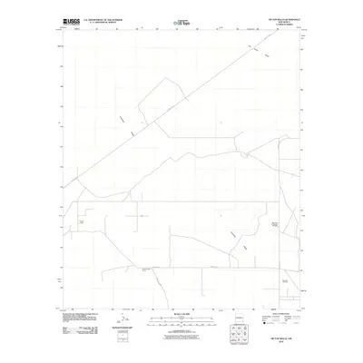
2010 Map of Tip Top Wells
USGS Topo · Published 2010About this map
Antelope Ridge defines the topography of this high desert section of Lea County, marking a stark landscape where petroleum extraction and ranching coexist. The presence of the Cruz Oil Field and Bell Lake Oil Field illustrates the region's industrial character during the early 21st century, showing how resource development has shaped the road network and land use. For those looking at local history, Brimminstool Ranch serves as a primary marker of settlement in this arid environment, situated near the intersection of County Rd-2 and Briminstool Rd. The vast San Simon Swale cuts across the northeastern portion of the sheet, providing a geographic counterpoint to the man-made infrastructure of oil rigs and pits, such as the Airport Pit ID Number 2901648, that dot the landscape.
Find a feature on this map
10 named features on this map. Tap any name to fly to it.
Don’t see what you’re looking for? This feature index may not catch every label — zoom into the map to look around manually.
Map Details
Editions of this 2010 Tip Top Wells Map
This is the sole edition of this map. No revisions or reprints were ever made.
Other maps of this area

1954 · Hobbs
USGS Topo · 1:250,000

1958 · Hobbs
USGS Topo · 1:250,000

1963 · Oil Center
USGS Topo · 1:62,500

1963 · Hat Mesa
USGS Topo · 1:62,500

1973 · Bell Lake
USGS Topo · 1:24,000

1973 · Paduca Breaks NW
USGS Topo · 1:24,000
1973 · Woodley Flat
USGS Topo · 1:24,000

1978 · Jal
USGS Topo · 1:100,000
1984 · Tip Top Wells
USGS Topo · 1:24,000
1984 · Grama Ridge
USGS Topo · 1:24,000