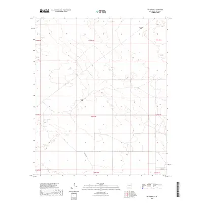
2023 Map of Tip Top Wells
USGS Topo · Published 2023About this map
Antelope Ridge and the broad depressions of the San Simon Swale define this arid landscape in Lea County, New Mexico. The terrain reflects the characteristic geography of the Permian Basin, where subtle elevation changes and natural basins are the primary landmarks. Human presence is marked by a network of ranch and energy roads, including Brinninstool Rd and the X-L Rd, which crisscross the expansive desert sections. The map detail highlights the Public Land Survey System grid, dividing the region into townships such as t23s r33e and t22s r34e, illustrating how this remote corner of the state is partitioned for land management and resource use in the early 21st century.
Find a feature on this map
16 named features on this map. Tap any name to fly to it.
Don’t see what you’re looking for? This feature index may not catch every label — zoom into the map to look around manually.
Map Details
Editions of this 2023 Tip Top Wells Map
This is the sole edition of this map. No revisions or reprints were ever made.
Other maps of this area

1954 · Hobbs
USGS Topo · 1:250,000

1958 · Hobbs
USGS Topo · 1:250,000

1963 · Oil Center
USGS Topo · 1:62,500

1963 · Hat Mesa
USGS Topo · 1:62,500

1973 · Bell Lake
USGS Topo · 1:24,000

1973 · Paduca Breaks NW
USGS Topo · 1:24,000
1973 · Woodley Flat
USGS Topo · 1:24,000

1978 · Jal
USGS Topo · 1:100,000
1984 · Tip Top Wells
USGS Topo · 1:24,000
1984 · Grama Ridge
USGS Topo · 1:24,000