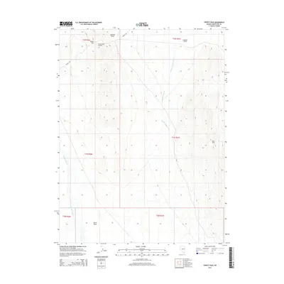
2014 Map of Tippett Pass
USGS Topo · Published 2014About this map
Tippett Pass and Twelvemile Summit serve as the primary topographic crossings through the Antelope Range in this high-desert portion of White Pine County. The landscape is defined by the drainage patterns of Antelope Valley Wash and Spring Valley Cr, which feed the broad basins of Antelope Valley and Spring Valley respectively. Human presence in this isolated terrain is marked by the winding path of Whiskey Rd, which navigates the northern slopes. The map reveals the stark geological transition from the central range to the distinct volcanic or sedimentary outcrops of the Red Hills in the southeast, illustrating a classic Great Basin environment where seasonal water flow dictates the geography.
Find a feature on this map
15 named features on this map. Tap any name to fly to it.
Don’t see what you’re looking for? This feature index may not catch every label — zoom into the map to look around manually.
Map Details
Editions of this 2014 Tippett Pass Map
This is the sole edition of this map. No revisions or reprints were ever made.
Other maps of this area

1956 · Ely
USGS Topo · 1:250,000

1959 · Ely
USGS Topo · 1:250,000

1963 · Ely
USGS Topo · 1:250,000
1982 · Kalamazoo Creek
USGS Topo · 1:24,000
1982 · Silver Canyon
USGS Topo · 1:24,000
1982 · Stonehouse
USGS Topo · 1:24,000
1986 · Big Hard Pan
USGS Topo · 1:24,000
1986 · Tippett Pass
USGS Topo · 1:24,000
1986 · Grass Valley Wash
USGS Topo · 1:24,000
1986 · White Cloud Point
USGS Topo · 1:24,000