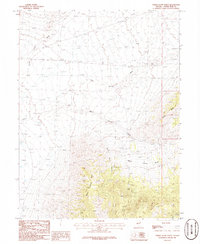
1986 Map of White Cloud Point
USGS Topo · Published 1986About this map
White Cloud Point stands as a prominent landmark in this high-elevation corner of White Pine County, where the desert floor meets the steep ascent of the mountain range. The 1980s landscape is defined by the arid expanse of Spring Valley to the west, punctuated by a significant geological Depression and several Dry Lakes. This survey captures a moment in Nevada's mining history, documenting a specific Mine Shaft and Prospect tucked within the folds of White Cloud Canyon. These features, along with Mike Springs, indicate the vital locations where water and minerals dictated human activity in an otherwise austere environment. The drainage patterns through White Cloud Basin and the lower Little Hills provide a clear view of the alluvial geography that characterizes this remote basin-and-range territory.
Find a feature on this map
11 named features on this map. Tap any name to fly to it.
Don’t see what you’re looking for? This feature index may not catch every label — zoom into the map to look around manually.
Map Details
Editions of this 1986 White Cloud Point Map
This is the sole edition of this map. No revisions or reprints were ever made.
Other maps of this area

1956 · Ely
USGS Topo · 1:250,000

1959 · Ely
USGS Topo · 1:250,000

1963 · Ely
USGS Topo · 1:250,000
1986 · Third Butte West
USGS Topo · 1:24,000
1986 · Big Hard Pan
USGS Topo · 1:24,000
1986 · Mormon Jack Pass
USGS Topo · 1:24,000
1986 · Tippett Pass
USGS Topo · 1:24,000
1986 · Grass Valley Wash
USGS Topo · 1:24,000
1986 · Third Butte East
USGS Topo · 1:24,000
1986 · Government Peak
USGS Topo · 1:24,000