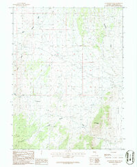
1986 Map of Government Peak
USGS Topo · Published 1986About this map
Government Peak stands as the primary landmark in this high-desert portion of White Pine County, overlooking a landscape defined by an intricate system of drainage washes and mountain canyons. Mapping from the 1980s reveals a network of primitive tracks and 4wd routes that navigate the varying elevations between Little Valley and the western slopes. Life in this arid environment is anchored by water sources like Cain Springs and a series of wells, which supported ranching or prospecting efforts in the region. The map tracks several major ephemeral waterways, including Tungstonia Wash and George Indian Wash, which carve through the terrain. To the southwest, the entrance to Cave Canyon and the Little Hills provide distinct geographic boundaries to this corner of the Nevada wilderness.
Find a feature on this map
13 named features on this map. Tap any name to fly to it.
Don’t see what you’re looking for? This feature index may not catch every label — zoom into the map to look around manually.
Map Details
Editions of this 1986 Government Peak Map
This is the sole edition of this map. No revisions or reprints were ever made.
Other maps of this area

1956 · Ely
USGS Topo · 1:250,000

1959 · Ely
USGS Topo · 1:250,000

1963 · Ely
USGS Topo · 1:250,000
1986 · Mormon Jack Pass
USGS Topo · 1:24,000
1986 · Grass Valley Wash
USGS Topo · 1:24,000
1986 · Spring Mountain
USGS Topo · 1:24,000
1986 · White Cloud Point
USGS Topo · 1:24,000
1986 · Third Butte East
USGS Topo · 1:24,000
1986 · Tin Springs Mountain
USGS Topo · 1:24,000
1986 · Blue Mass Canyon
USGS Topo · 1:24,000