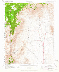
1952 Map of Tippipah Spring
USGS Topo · Published 1964About this map
The Nevada Proving Grounds occupy the eastern expanse of this 1952 landscape, a period when the region was central to the atomic age. The high desert terrain is defined by dramatic geologic formations such as Syncline Ridge and the volcanic heights of Shoshone Mtn and Mine Mountain. While the Mercury Highway provides the primary north-south corridor through the flats, the interior is accessed by the Tippipah Road, which winds toward isolated water sources like Tippipah Spring and Whiterock Spring. These springs, including Captain Jack Spring and Oak Spring, represent critical landmarks in an otherwise arid environment marked by the vast Bombing and Las Vegas Gunnery Range. The juxtaposition of these natural seeps against the infrastructure of modern military testing sites offers a distinct look at the mid-century transformation of Nye County.
Find a feature on this map
20 named features on this map. Tap any name to fly to it.
Don’t see what you’re looking for? This feature index may not catch every label — zoom into the map to look around manually.
Map Details
Editions of this 1952 Tippipah Spring Map
3 editions found

Other maps of this area

1907 · Las Vegas
USGS Topo · 1:250,000

1908 · Kawich
USGS Topo · 1:250,000

1908 · Furnace Creek
USGS Topo · 1:250,000

1908 · Las Vegas
USGS Topo · 1:250,000

1910 · Furnace Creek
USGS Topo · 1:250,000

1942 · Emigrant Valley
USGS Topo · 1:125,000

1942 · Indian Spring
USGS Topo · 1:125,000

1942 · Wheelbarrow Peak
USGS Topo · 1:125,000

1942 · Skull Mountain
USGS Topo · 1:125,000

1948 · Death Valley
USGS Topo · 1:250,000