
1890 Map of Tipton
USGS Topo · Published 1890About this map
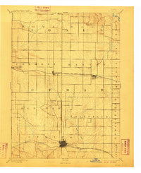
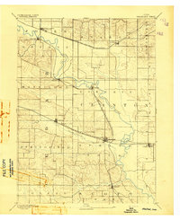
The county seat of Tipton serves as the primary hub of this 1889 survey, where a well-defined street grid meets the Burlington Cedar Rapids and Northern Railroad. The landscape is largely defined by the late nineteenth-century rail expansion, with the Chicago and North-Western Railroad cutting a sharp east-west line through the northern half of the county. This corridor facilitated the growth of shipping points like Mechanicsville, Stanwood, and Clarence, which are shown here in their early stages of development.
Find a feature on this map
20 named features on this map. Tap any name to fly to it.
Don’t see what you’re looking for? This feature index may not catch every label — zoom into the map to look around manually.
Map Details
Editions of this 1890 Tipton Map
2 editions found
Other maps of this area

1889 · Tipton
USGS Topo · 1:62,500

1890 · Durant
USGS Topo · 1:62,500

1890 · Anamosa
USGS Topo · 1:62,500
1891 · Monticello
USGS Topo · 1:62,500

1891 · Mechanicsville
USGS Topo · 1:62,500

1891 · Wilton Junction
USGS Topo · 1:62,500
1891 · Baldwin
USGS Topo · 1:62,500
1892 · Wheatland
USGS Topo · 1:62,500
1894 · Wheatland
USGS Topo · 1:62,500

1894 · Mechanicsville
USGS Topo · 1:62,500