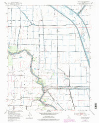
1952 Map of Tisdale Weir
USGS Topo · Published 1974About this map
The Sacramento River defines the western edge of this agricultural landscape, where intricate water management systems like the Tisdale Weir and the Tisdale By-Pass protected the surrounding valley. In the early 1950s, the region was a network of river-oriented landmarks and irrigation infrastructure, including the Sutter By-Pass and the Wadsworth Canal. Land use is marked by small settlements and shipping points such as Tisdale, Hinsdale, and Fraziers Landing. Education and transit are represented by the Winship School and the Southern Pacific railroad line running north-south through the flats. This survey documents the transition of the riverbanks, noting the Eddys Ferry (Site), and preserves the layout of the Sutter National Wildlife Refuge as it integrated with the productive lands of the Jimeno Basin.
Find a feature on this map
33 named features on this map. Tap any name to fly to it.
Don’t see what you’re looking for? This feature index may not catch every label — zoom into the map to look around manually.
Map Details
Editions of this 1952 Tisdale Weir Map
3 editions found
Other maps of this area

1888 · Marysville
USGS Topo · 1:125,000

1891 · Marysville
USGS Topo · 1:125,000

1894 · Marysville
USGS Topo · 1:125,000

1895 · Marysville
USGS Topo · 1:125,000

1907 · Dunnigan
USGS Topo · 1:62,500

1910 · Marcuse
USGS Topo · 1:31,680

1911 · Sutter
USGS Topo · 1:31,680

1911 · Grimes
USGS Topo · 1:31,680

1911 · Gilsizer Slough
USGS Topo · 1:31,680

1912 · Marysville Buttes
USGS Topo · 1:31,680