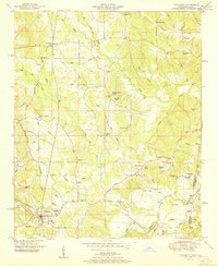
1951 Map of Tishomingo
USGS Topo · Published 1951About this map
Tishomingo serves as the primary hub of this 1951 topographic survey, situated at the intersection of the Illinois Central railroad and the Natchez Trace. The landscape is defined by the Tennessee Valley Divide, which separates the northern drainage of Cripple Deer Creek from the southern flow toward Bear Creek. The map records a dense network of rural social infrastructure, from Cartersville School in the north to the St Peters Church area near Petertown on the eastern border. This transition point between Mississippi and Alabama is marked by numerous family-named landmarks and water sources like Milford Spring and Cave Spring. Of particular interest to local historians is an Indian mound located near the state line, suggesting the long-standing significance of the high ground overlooking the creek valleys before the modern era of rail and road transportation took hold.
Find a feature on this map
80 named features on this map. Tap any name to fly to it.
Don’t see what you’re looking for? This feature index may not catch every label — zoom into the map to look around manually.
Map Details
Editions of this 1951 Tishomingo Map
This is the sole edition of this map. No revisions or reprints were ever made.
Other maps of this area

1911 · Iuka
USGS Topo · 1:48,000

1914 · Iuka
USGS Topo · 1:62,500

1935 · Holcut
USGS Topo · 1:24,000

1935 · Iuka
USGS Topo · 1:24,000

1935 · Leedy
USGS Topo · 1:24,000

1935 · Pleasant Site
USGS Topo · 1:24,000

1936 · Margerum
USGS Topo · 1:24,000

1936 · Belmont
USGS Topo · 1:24,000

1936 · Bishop
USGS Topo · 1:24,000

1936 · Tishomingo
USGS Topo · 1:24,000