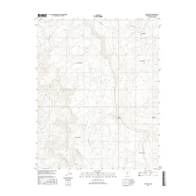
2017 Map of Toadlena
USGS Topo · Published 2017About this map
Toadlena sits at the high-elevation eastern edge of the Chuska Mountains, where the high desert meets steep mountain drainage. This landscape is defined by its water sources, including the prominent Toadlena Lake and several critical watering points such as Big Water Spring and Vicenti Spring. The map documents a network of Indian Service Routes, including Indian Svc Rte 19 and Indian Svc Rte 30, which facilitate movement across the rugged topography. The presence of the Po (Post Office) in Toadlena signifies its role as a local center for the surrounding community. Seasonal drainage patterns are clearly visible through the courses of Captain Tom Wash and To-dil-hil Wash, which channel runoff from the Chuska peaks toward the flatter lands to the east.
Find a feature on this map
19 named features on this map. Tap any name to fly to it.
Don’t see what you’re looking for? This feature index may not catch every label — zoom into the map to look around manually.
Map Details
Editions of this 2017 Toadlena Map
This is the sole edition of this map. No revisions or reprints were ever made.
Other maps of this area

1889 · Chaco
USGS Topo · 1:250,000

1892 · Chaco
USGS Topo · 1:250,000

1892 · Canyon De Chelly
USGS Topo · 1:250,000

1953 · Sanostee
USGS Topo · 1:62,500

1954 · Shiprock
USGS Topo · 1:250,000

1955 · Sonsala Butte 4 SE
USGS Topo · 1:24,000

1955 · Sonsala Butte 1 SE
USGS Topo · 1:24,000
1955 · Sonsala Butte 4 NE
USGS Topo · 1:24,000
1955 · Sonsela Buttes
USGS Topo · 1:62,500
1955 · Lukachukai
USGS Topo · 1:62,500