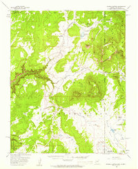
1955 Map of Sonsela Buttes
USGS Topo · Published 1959About this map
Sonsela Buttes rise prominently from the high-altitude landscape of the Navajo Indian Reservation along the Arizona-New Mexico border. This mid-1950s survey documents a network of seasonal washes and alpine springs, including the distinctive Black Salt Spring and Hidden Spring. The high country is defined by the Tunitcha Mountains and the dramatic drop-offs of the Palisade Cliffs and Beshthalthaa Cliffs.
Find a feature on this map
38 named features on this map. Tap any name to fly to it.
Don’t see what you’re looking for? This feature index may not catch every label — zoom into the map to look around manually.
Map Details
Editions of this 1955 Sonsela Buttes Map
3 editions found
Other maps of this area

1886 · Wingate
USGS Topo · 1:250,000

1886 · Fort Defiance
USGS Topo · 1:250,000

1889 · Chaco
USGS Topo · 1:250,000

1892 · Fort Defiance
USGS Topo · 1:250,000

1892 · Wingate
USGS Topo · 1:250,000

1892 · Chaco
USGS Topo · 1:250,000

1892 · Canyon De Chelly
USGS Topo · 1:250,000

1953 · Sanostee
USGS Topo · 1:62,500

1954 · Shiprock
USGS Topo · 1:250,000

1954 · Gallup
USGS Topo · 1:250,000
Featured Places
- Shiprock Agency
- Chinle Agency, AZ
- Fort Defiance Agency
- Wheatfields, Chinle Agency
- Milkwater, Fort Defiance Agency