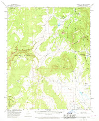
1955 Map of Sonsela Buttes
USGS Topo · Published 1969About this map
Sonsela Buttes rise prominently above the high-desert landscape of the Navajo Indian Reservation, straddling the border of Arizona and New Mexico. This mid-century topographical record details a transition from the elevated Tunitcha Mountains in the north to the distinctive geological formations of Canyon De Chelly National Monument in the west. The presence of the Chee Dodge Ranch and settlements like Lower Wheatfields illustrates the localized grazing and ranching culture of the era. Water management is a central theme of this landscape, evidenced by systems like the ditch near Wheatfields Lake and scattered reservoirs and springs that supported life across Prairie Dog Valley and Yellow Valley. Small but significant details, including isolated graves and a gaging station on Whisky Creek, provide points of interest for genealogists and local historians.
Find a feature on this map
43 named features on this map. Tap any name to fly to it.
Don’t see what you’re looking for? This feature index may not catch every label — zoom into the map to look around manually.
Map Details
Editions of this 1955 Sonsela Buttes Map
3 editions found
Other maps of this area

1886 · Wingate
USGS Topo · 1:250,000

1886 · Fort Defiance
USGS Topo · 1:250,000

1889 · Chaco
USGS Topo · 1:250,000

1892 · Fort Defiance
USGS Topo · 1:250,000

1892 · Wingate
USGS Topo · 1:250,000

1892 · Chaco
USGS Topo · 1:250,000

1892 · Canyon De Chelly
USGS Topo · 1:250,000

1953 · Sanostee
USGS Topo · 1:62,500

1954 · Shiprock
USGS Topo · 1:250,000

1954 · Gallup
USGS Topo · 1:250,000
Featured Places
- Shiprock Agency
- Chinle Agency, AZ
- Fort Defiance Agency
- Wheatfields, Chinle Agency
- Milkwater, Fort Defiance Agency