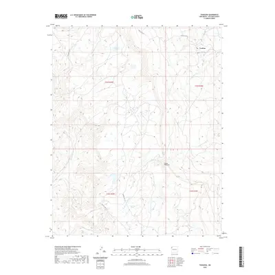
2020 Map of Toadlena
USGS Topo · Published 2020About this map
Toadlena sits at the base of the Chuska Mountains in San Juan County, New Mexico, serving as a focal point for this high-desert landscape. The area is defined by a complex network of seasonal drainages and washes, including the prominent Captain Tom Wash and To-diz-bil Wash, which cut through the arid terrain. To the west, the topography rises sharply toward the forested slopes of the Chuska range, where the higher elevation supports features like Toadlena Lake. The presence of Big Water Spring and multiple creeks such as Whiskey Cr and Little Whiskey Cr highlights the critical importance of water sources in this region. This modern survey illustrates the persistent connection between the settlement and its geographical environment, linked by routes like Old Mountain Rd and several Indian Service Routes that navigate the varied elevations of the Shiprock Agency area.
Find a feature on this map
17 named features on this map. Tap any name to fly to it.
Don’t see what you’re looking for? This feature index may not catch every label — zoom into the map to look around manually.
Map Details
Editions of this 2020 Toadlena Map
This is the sole edition of this map. No revisions or reprints were ever made.
Other maps of this area

1889 · Chaco
USGS Topo · 1:250,000

1892 · Chaco
USGS Topo · 1:250,000

1892 · Canyon De Chelly
USGS Topo · 1:250,000

1953 · Sanostee
USGS Topo · 1:62,500

1954 · Shiprock
USGS Topo · 1:250,000

1955 · Sonsala Butte 4 SE
USGS Topo · 1:24,000

1955 · Sonsala Butte 1 SE
USGS Topo · 1:24,000
1955 · Sonsala Butte 4 NE
USGS Topo · 1:24,000
1955 · Sonsela Buttes
USGS Topo · 1:62,500
1955 · Lukachukai
USGS Topo · 1:62,500