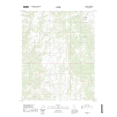
2023 Map of Toadlena
USGS Topo · Published 2023About this map
Toadlena sits at the eastern edge of the high mountain ranges within the Navajo Nation, where the high peaks of the Tunitcha Mountains and Chuska Mountains give way to a network of drainage washes. The settlement is centered near the intersection of several tribal routes, including Indian Svc Rte 19 and Indian Svc Rte 191. Local history is anchored at the Toadlena Northwest Community Cem and the nearby Toadlena Lake. The landscape is defined by its water sources, from the seasonal flow of To-dil-hil Wash and Captain Tom Wash to the reliable Big Water Spring. Higher elevations are marked by the headwaters of Whiskey Creek and Little Whiskey Creek, tracing the steep descent from the timbered heights down toward the arid valley floor. This survey documents the complex topography of the eastern Chuska slope, where traditional land use and modern infrastructure meet.
Find a feature on this map
18 named features on this map. Tap any name to fly to it.
Don’t see what you’re looking for? This feature index may not catch every label — zoom into the map to look around manually.
Map Details
Editions of this 2023 Toadlena Map
This is the sole edition of this map. No revisions or reprints were ever made.
Other maps of this area

1889 · Chaco
USGS Topo · 1:250,000

1892 · Chaco
USGS Topo · 1:250,000

1892 · Canyon De Chelly
USGS Topo · 1:250,000

1953 · Sanostee
USGS Topo · 1:62,500

1954 · Shiprock
USGS Topo · 1:250,000

1955 · Sonsala Butte 4 SE
USGS Topo · 1:24,000

1955 · Sonsala Butte 1 SE
USGS Topo · 1:24,000
1955 · Sonsala Butte 4 NE
USGS Topo · 1:24,000
1955 · Sonsela Buttes
USGS Topo · 1:62,500
1955 · Lukachukai
USGS Topo · 1:62,500