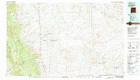
1980 Map of Toadlena
USGS Topo · Published 1981About this map
The Chuska Mountains dominate the western horizon of this 1980 landscape, providing a dramatic backdrop to the Navajo Indian Reservation. This map reveals a network of high-desert settlements and trading posts connected by Us 666, including Toadlena, Two Grey Hills, and Sheep Springs. The geography is defined by a complex system of seasonal watercourses such as the Chaco River and Naschitti Wash, which carve through the arid terrain toward the eastern flats.
Find a feature on this map
60 named features on this map. Tap any name to fly to it.
Don’t see what you’re looking for? This feature index may not catch every label — zoom into the map to look around manually.
Map Details
Editions of this 1980 Toadlena Map
3 editions found
Other maps of this area

1883 · Mt. Taylor
USGS Topo · 1:250,000

1886 · Wingate
USGS Topo · 1:250,000

1886 · Mt. Taylor
USGS Topo · 1:250,000

1886 · Fort Defiance
USGS Topo · 1:250,000

1889 · Largo
USGS Topo · 1:250,000

1889 · Chaco
USGS Topo · 1:250,000

1892 · Fort Defiance
USGS Topo · 1:250,000

1892 · Wingate
USGS Topo · 1:250,000

1892 · Chaco
USGS Topo · 1:250,000

1892 · Canyon De Chelly
USGS Topo · 1:250,000
Featured Places
- Shiprock Agency
- Chinle Agency, AZ
- Fort Defiance Agency
- Eastern Navajo Agency, NM
- Sanostee, Shiprock Agency