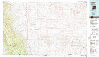
1980 Map of Toadlena
USGS Topo · Published 1992About this map
The high desert landscape of the Navajo Indian Reservation is defined by a vast network of drainage washes and striking geological landmarks in this 1980 survey. Anchored by the Chuska Mountains to the west, the area features prominent volcanic plugs and mesas such as Bennett Peak, Ford Butte, and Rock Mesa. The map captures the alignment of US Highway 666 as it connects the settlements of Naschitti, Sheep Springs, and Newcomb, providing a window into the region's transport corridor between the mountains and the Chaco River. In the southeast, the boundaries of Chaco Culture National Historical Park and the complex badlands of the Bisti area highlight the transition from cultural heritage sites to the wide, arid expanses of Split Lip Flats and Kim-me-ni-oli Valley. Local commerce and resource extraction are represented by an Oil Field and scattered trading posts like Two Grey Hills.
Find a feature on this map
56 named features on this map. Tap any name to fly to it.
Don’t see what you’re looking for? This feature index may not catch every label — zoom into the map to look around manually.
Map Details
Editions of this 1980 Toadlena Map
3 editions found
Other maps of this area

1883 · Mt. Taylor
USGS Topo · 1:250,000

1886 · Wingate
USGS Topo · 1:250,000

1886 · Mt. Taylor
USGS Topo · 1:250,000

1886 · Fort Defiance
USGS Topo · 1:250,000

1889 · Largo
USGS Topo · 1:250,000

1889 · Chaco
USGS Topo · 1:250,000

1892 · Fort Defiance
USGS Topo · 1:250,000

1892 · Wingate
USGS Topo · 1:250,000

1892 · Chaco
USGS Topo · 1:250,000

1892 · Canyon De Chelly
USGS Topo · 1:250,000
Featured Places
- Shiprock Agency
- Chinle Agency, AZ
- Fort Defiance Agency
- Eastern Navajo Agency, NM
- Sanostee, Shiprock Agency