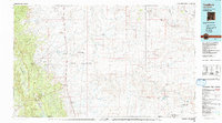
1980 Map of Toadlena
USGS Topo · Published 1992About this map
The Chuska Mountains dominate the western horizon of this 1980 survey, overlooking a vast landscape where the Navajo Indian Reservation meets the early boundaries of Chaco Culture National Historical Park. The settlement pattern follows the drainage of the Chaco River and its numerous washes, including the Sanostee Wash and Bisti Wash. Community life is anchored by traditional centers like Toadlena, Two Grey Hills, and the Tsin-nas-kin Trading Post, all linked by the primary corridor of Highway 666. The terrain transitions from high mesas like Rock Mesa and Grey Mesa to the striking formation known as The Pillar, illustrating the geological diversity of the San Juan Basin before modern development altered these remote reaches of New Mexico.
Find a feature on this map
36 named features on this map. Tap any name to fly to it.
Don’t see what you’re looking for? This feature index may not catch every label — zoom into the map to look around manually.
Map Details
Editions of this 1980 Toadlena Map
3 editions found
Other maps of this area

1883 · Mt. Taylor
USGS Topo · 1:250,000

1886 · Wingate
USGS Topo · 1:250,000

1886 · Mt. Taylor
USGS Topo · 1:250,000

1886 · Fort Defiance
USGS Topo · 1:250,000

1889 · Largo
USGS Topo · 1:250,000

1889 · Chaco
USGS Topo · 1:250,000

1892 · Fort Defiance
USGS Topo · 1:250,000

1892 · Wingate
USGS Topo · 1:250,000

1892 · Chaco
USGS Topo · 1:250,000

1892 · Canyon De Chelly
USGS Topo · 1:250,000
Featured Places
- Shiprock Agency
- Chinle Agency, AZ
- Fort Defiance Agency
- Eastern Navajo Agency, NM
- Sanostee, Shiprock Agency