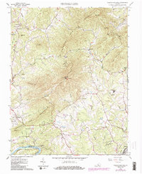
1963 Map of Tobacco Row Mtn
USGS Topo · Published 1986About this map
Tobacco Row Mountain dominates this Amherst County landscape, forming a prominent ridge that defines the local geography. The map reveals a mid-century rural economy anchored by small settlements like Elon, Pleasant View, and Monroe, where local commerce centered on locations such as Hicks Store and Crawfords Store. The southern edge of the quadrangle is bounded by the James River, where the Chesapeake and Ohio and Southern railroads intersect, highlighting the area's importance as a transportation corridor. Cultural and spiritual life is well-documented through numerous landmarks, including the Father Judge Mission Seminary and various country churches like Little Bethel Ch and New Prospect Ch. Family-named sites like Gatewood Cem and Hudson Cem provide significant detail for genealogical research in this Piedmont region.
Find a feature on this map
69 named features on this map. Tap any name to fly to it.
Don’t see what you’re looking for? This feature index may not catch every label — zoom into the map to look around manually.
Map Details
Editions of this 1963 Tobacco Row Mtn Map
4 editions found
Other maps of this area

1892 · Lynchburg
USGS Topo · 1:125,000

1894 · Lexington
USGS Topo · 1:125,000

1935 · Buena Vista
USGS Topo · 1:48,000

1935 · Amherst
USGS Topo · 1:48,000

1939 · Amherst
USGS Topo · 1:62,500

1939 · Buena Vista
USGS Topo · 1:62,500

1940 · Buena Vista
USGS Topo · 1:62,500

1944 · Lynchburg
USGS Topo · 1:62,500

1947 · Roanoke
USGS Topo · 1:250,000

1950 · Goode
USGS Topo · 1:62,500