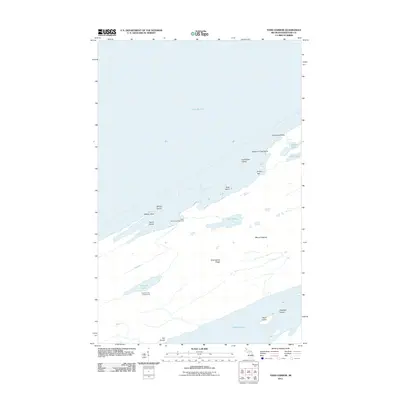
2011 Map of Todd Harbor
USGS Topo · Published 2011About this map
Isle Royale stands as the central focus of this 2011 topographic survey, showcasing the complex coastline and interior ridges of this northern archipelago. The landscape is defined by the prominent Greenstone Ridge and elevations such as Mount Siskiwit, which look out over a network of interior waters including Siskiwit Lake, Lake Harvey, and Hatchet Lake. This map captures the area's role as a primitive retreat, marking the Todd Harbor Campground and Hatchet Lake Campground along the northern shore. The surrounding waters of Lake Superior are dotted with numerous landmarks such as Wilson Island, Taylor Island, and the uniquely named Teakettle Island, while coastal features like Kamloops Point and Twelve O'Clock Point define the jagged northern perimeter. The presence of both Florence Bay and Pickett Bay highlights the protected coves that characterize the Todd Harbor region.
Find a feature on this map
24 named features on this map. Tap any name to fly to it.
Don’t see what you’re looking for? This feature index may not catch every label — zoom into the map to look around manually.
Map Details
Editions of this 2011 Todd Harbor Map
This is the sole edition of this map. No revisions or reprints were ever made.
Other maps of this area

1958 · Hancock
USGS Topo · 1:250,000

1959 · Fort William
USGS Topo · 1:250,000

1960 · Hancock
USGS Topo · 1:250,000

1961 · Hancock
USGS Topo · 1:250,000

1966 · Hancock
USGS Topo · 1:250,000

1968 · Fort William
USGS Topo · 1:250,000

1985 · Todd Harbor
USGS Topo · 1:100,000

1985 · Siskiwit Bay
USGS Topo · 1:100,000
1985 · Lake Richie
USGS Topo · 1:24,000
1985 · Todd Harbor
USGS Topo · 1:24,000