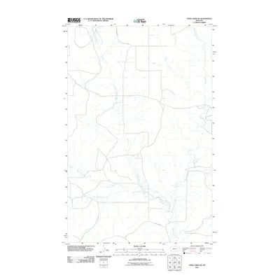
2011 Map of Todd Lakes SE
USGS Topo · Published 2011About this map
Wolf Creek and its many meandering tributaries define this portion of the Wolf Point District in northeastern Montana. The landscape is characterized by the complex convergence of the Middle Fork Wolf Creek, West Fork Wolf Creek, East Fork Wolf Creek, and Dry Fork Wolf Creek. This drainage network suggests a rugged, eroded terrain where seasonal water flow has carved deep into the plains. Human intervention is sparse, represented primarily by the utilitarian grid of rural transport routes. County Line Rd and Wolf Creek Rd provide the primary access through this open country, following the natural contours of the land and the boundaries between jurisdictions. The lack of concentrated settlements or industrial markers emphasizes the area's enduring character as an expansive rangeland dominated by natural watercourses.
Find a feature on this map
7 named features on this map. Tap any name to fly to it.
Don’t see what you’re looking for? This feature index may not catch every label — zoom into the map to look around manually.
Map Details
Editions of this 2011 Todd Lakes SE Map
This is the sole edition of this map. No revisions or reprints were ever made.
Other maps of this area

1910 · Todd Lakes
USGS Topo · 1:62,500

1915 · Tule Valley
USGS Topo · 1:62,500

1915 · Oswego
USGS Topo · 1:62,500

1915 · Todd Lakes
USGS Topo · 1:62,500

1916 · Wolf Point
USGS Topo · 1:62,500

1954 · Wolf Point
USGS Topo · 1:250,000

1958 · Wolf Point
USGS Topo · 1:250,000

1972 · Flynn Creek North
USGS Topo · 1:24,000
1972 · Oswego NW
USGS Topo · 1:24,000
1972 · Wolf Point NW
USGS Topo · 1:24,000