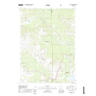
2017 Map of Togwotee Pass
USGS Topo · Published 2017About this map
Togwotee Pass serves as a critical mountain crossing along the boundary between the Teton National Forest and Shoshone National Forest. This high-altitude landscape is defined by the Continental Divide, which separates the drainages of Blackrock Cr and Brooks Lake Cr. The terrain is marked by dramatic geological formations, including the sheer Breccia Cliffs and the summit of Breccia Peak, which overlook a network of alpine waters. A system of historical and recreational paths, such as the Yellowstone Trail and the Continental Divide National Scenic Trail, connects remote basins and lakes. For the researcher, the map documents the intricate relationship between high-country hydrology and transit, showing how trails like the Jade Lake Trail navigate the steep drops between Upper Jade Lake and Lower Jade Lake near the Fremont and Teton county line.
Find a feature on this map
39 named features on this map. Tap any name to fly to it.
Don’t see what you’re looking for? This feature index may not catch every label — zoom into the map to look around manually.
Map Details
Editions of this 2017 Togwotee Pass Map
This is the sole edition of this map. No revisions or reprints were ever made.
Other maps of this area
1902 · Mt Leidy
USGS Topo · 1:125,000
1905 · Younts Peak
USGS Topo · 1:125,000
1907 · Younts Peak
USGS Topo · 1:125,000

1955 · Driggs
USGS Topo · 1:250,000

1955 · Thermopolis
USGS Topo · 1:250,000
1956 · Kisinger Lakes
USGS Topo · 1:24,000
1956 · Dundee Meadows
USGS Topo · 1:24,000
1958 · Driggs
USGS Topo · 1:250,000
1958 · Thermopolis
USGS Topo · 1:250,000
1962 · Thermopolis
USGS Topo · 1:250,000