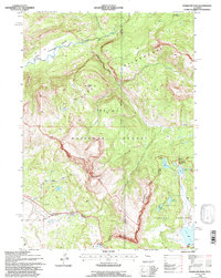
1991 Map of Togwotee Pass
USGS Topo · Published 1997About this map
Togwotee Pass serves as the high mountain threshold where the headwaters of the Wind River meet the western drainages of the Teton National Forest and Shoshone National Forest. This high-altitude landscape is defined by the Continental Divide, which traces a jagged path between Teton Co and Fremont Co. The terrain is dominated by the massive Breccia Cliffs and the towering Breccia Peak, with the high peaks of Simpson Peaks looking out over the drainage of Crib Creek. Significant alpine water features include the cluster of Brooks Lake, Upper Brooks Lakes, and the deep turquoise waters of Lower Jade Lake and Upper Jade Lake. Within the Teton Wilderness, the map identifies notable natural landmarks such as Holmes Cave and the expansive Pendergraft Meadow along the South Fork Buffalo Fork.
Find a feature on this map
34 named features on this map. Tap any name to fly to it.
Don’t see what you’re looking for? This feature index may not catch every label — zoom into the map to look around manually.
Map Details
Editions of this 1991 Togwotee Pass Map
This is the sole edition of this map. No revisions or reprints were ever made.
Other maps of this area

1902 · Mt Leidy
USGS Topo · 1:125,000

1905 · Younts Peak
USGS Topo · 1:125,000

1907 · Younts Peak
USGS Topo · 1:125,000

1955 · Driggs
USGS Topo · 1:250,000

1955 · Thermopolis
USGS Topo · 1:250,000

1956 · Kisinger Lakes
USGS Topo · 1:24,000
1956 · Dundee Meadows
USGS Topo · 1:24,000

1958 · Driggs
USGS Topo · 1:250,000

1958 · Thermopolis
USGS Topo · 1:250,000

1962 · Thermopolis
USGS Topo · 1:250,000