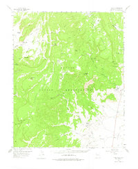
1955 Map of Tohatchi
USGS Topo · Published 1975About this map
Chuska Mountains and the elevated Manuelito Plateau dominate this 1955 survey of the Navajo Indian Reservation. The settlement of Tohatchi serves as the primary hub on the eastern edge of the quadrangle, situated where the high country meets the Tohatchi Flats. The landscape is defined by a complex network of seasonal drainage systems, including Squirrel Springs Wash and Mexican Springs Wash, which have carved deep canyons like Crevasse Canyon and Windy Canyon into the plateau.
Find a feature on this map
38 named features on this map. Tap any name to fly to it.
Don’t see what you’re looking for? This feature index may not catch every label — zoom into the map to look around manually.
Map Details
Editions of this 1955 Tohatchi Map
2 editions found

Other maps of this area

1886 · Wingate
USGS Topo · 1:250,000

1886 · Fort Defiance
USGS Topo · 1:250,000

1889 · Chaco
USGS Topo · 1:250,000

1892 · Fort Defiance
USGS Topo · 1:250,000

1892 · Wingate
USGS Topo · 1:250,000

1892 · Chaco
USGS Topo · 1:250,000

1892 · Canyon De Chelly
USGS Topo · 1:250,000

1954 · Shiprock
USGS Topo · 1:250,000

1954 · Gallup
USGS Topo · 1:250,000

1955 · Zith-Tusayan Butte 4 NE
USGS Topo · 1:24,000
Featured Places
- Fort Defiance Agency
- Tohatchi, Fort Defiance Agency
- Mexican Springs, Fort Defiance Agency
- McKinley County, NM
- United States