
1931 Map of Tokio
USGS Topo · Published 1931About this map
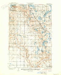
Fort Totten P O and the nearby Fort Totten Agency serve as the historical anchors of this prairie landscape, situated on the southern shores of Devils Lake. This 1920s survey illustrates a region defined by its transition from the Devils Lake Indian Reservation to organized townships like Mission and Wood Lake. The terrain is characterized by a complex network of glacial lakes and wetlands, including Black Tiger Bay and Horseshoe Lake, which sit north of the winding Sheyenne River.
Find a feature on this map
31 named features on this map. Tap any name to fly to it.
Don’t see what you’re looking for? This feature index may not catch every label — zoom into the map to look around manually.
Map Details
Editions of this 1931 Tokio Map
2 editions found
Other maps of this area

1928 · Tokio
USGS Topo · 1:62,500

1930 · Hamar
USGS Topo · 1:62,500

1931 · Oberon
USGS Topo · 1:62,500

1931 · Devils Lake
USGS Topo · 1:62,500

1932 · Grahams Island
USGS Topo · 1:62,500

1944 · Brantford
USGS Topo · 1:62,500

1946 · Brantford
USGS Topo · 1:62,500

1948 · New Rockford
USGS Topo · 1:62,500

1950 · New Rockford NE
USGS Topo · 1:24,000

1950 · Brantford NW
USGS Topo · 1:24,000
Featured Places
- Wood Lake District, ND
- St. Michael District, ND
- Fort Totten District, ND
- St. Michael, St. Michael District
- Tokio, ND