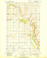
1950 Map of Tokio SW
USGS Topo · Published 1950About this map
The Sheyenne River winds through this landscape, marking the divide between Benson and Eddy counties during the mid-century. This survey, part of the Missouri River Basin development program, captures a rural prairie environment defined by the Old Indian Reservation Bdy and scattered agricultural landmarks. Local infrastructure is anchored by a series of one-room schoolhouses, including School No 1, School No 2, and School No 4, which served the farming families of the Bush and Hills regions.
Find a feature on this map
19 named features on this map. Tap any name to fly to it.
Don’t see what you’re looking for? This feature index may not catch every label — zoom into the map to look around manually.
Map Details
Editions of this 1950 Tokio SW Map
This is the sole edition of this map. No revisions or reprints were ever made.
Other maps of this area

1928 · Tokio
USGS Topo · 1:62,500

1931 · Oberon
USGS Topo · 1:62,500

1931 · Tokio
USGS Topo · 1:62,500

1944 · Brantford
USGS Topo · 1:62,500

1946 · Brantford
USGS Topo · 1:62,500

1948 · New Rockford
USGS Topo · 1:62,500

1950 · New Rockford NE
USGS Topo · 1:24,000

1950 · Brantford NW
USGS Topo · 1:24,000

1950 · Sheyenne
USGS Topo · 1:24,000

1950 · Brantford NE
USGS Topo · 1:24,000