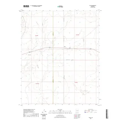
2020 Map of Tolar
USGS Topo · Published 2020About this map
Tolar sits at the heart of this high-plains landscape, situated along a primary transportation corridor that traverses the undulating terrain of eastern New Mexico. The map documents a rural environment where life follows the natural contours of ephemeral waterways like Painter Jim Cr and Sand Cr. Evidence of the area's established community is centered at the Tolar Cem, located just south of the main settlement area near Roosevelt Road 12 N. The boundary between De Baca and Roosevelt counties bisects the quadrangle, highlighting the intersection of administrative lines and natural features such as Stinking Spring and the drainage of Alamosa Cr. This 2020 survey illustrates a quiet ranching landscape defined by expansive open spaces and a network of named county roads like Cedar Post Rd and Rousing Rd.
Find a feature on this map
18 named features on this map. Tap any name to fly to it.
Don’t see what you’re looking for? This feature index may not catch every label — zoom into the map to look around manually.
Map Details
Editions of this 2020 Tolar Map
This is the sole edition of this map. No revisions or reprints were ever made.
Other maps of this area

1954 · Fort Sumner
USGS Topo · 1:250,000

1954 · Clovis
USGS Topo · 1:250,000

1958 · Fort Sumner
USGS Topo · 1:250,000

1958 · Clovis
USGS Topo · 1:250,000

1968 · Lomas Gatos
USGS Topo · 1:24,000

1968 · Candy Mesa
USGS Topo · 1:24,000

1968 · Taiban
USGS Topo · 1:24,000

1973 · Tolar
USGS Topo · 1:24,000

1973 · Krider
USGS Topo · 1:24,000
1973 · Peach Canyon
USGS Topo · 1:24,000