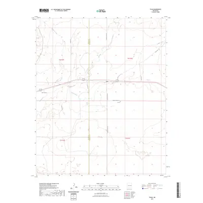
2023 Map of Tolar
USGS Topo · Published 2023About this map
The settlement of Tolar sits along the shared boundary of De Baca and Roosevelt counties, serving as a focal point for this expansive section of the High Plains. The landscape is defined by the drainage networks of Painter Jim Creek, Sand Creek, and Alamosa Creek, which carve subtle relief into the terrain as they flow toward the southeast. Local infrastructure is primarily composed of rural routes such as Black Hat Rd and Cedar Post Rd, reflecting a ranching or agricultural layout typical of this region.
Find a feature on this map
19 named features on this map. Tap any name to fly to it.
Don’t see what you’re looking for? This feature index may not catch every label — zoom into the map to look around manually.
Map Details
Editions of this 2023 Tolar Map
This is the sole edition of this map. No revisions or reprints were ever made.
Other maps of this area

1954 · Fort Sumner
USGS Topo · 1:250,000

1954 · Clovis
USGS Topo · 1:250,000

1958 · Fort Sumner
USGS Topo · 1:250,000

1958 · Clovis
USGS Topo · 1:250,000

1968 · Lomas Gatos
USGS Topo · 1:24,000

1968 · Candy Mesa
USGS Topo · 1:24,000

1968 · Taiban
USGS Topo · 1:24,000

1973 · Tolar
USGS Topo · 1:24,000

1973 · Krider
USGS Topo · 1:24,000
1973 · Peach Canyon
USGS Topo · 1:24,000