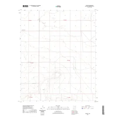
2020 Map of Tolar SE
USGS Topo · Published 2020About this map
The Mesa rises as the most prominent geographic feature in this section of the Llano Estacado, its contours defining the southern half of the quadrangle. The surrounding landscape is etched by drainage patterns like Chapman Draw, which cuts through the northwestern corner of the terrain. The map reflects a structured, rural grid typical of Roosevelt County, where the Public Land Survey System has dictated the placement of linear transport corridors such as N Roosevelt Road A Ve, N Roosevelt Road 1, and N Roosevelt Road 3. This 2020 survey documents the intersection of modern county infrastructure and natural landforms in an area characterized by township and range boundaries, highlighting the relationship between the high plains topography and the rectangular road network of eastern New Mexico.
Find a feature on this map
11 named features on this map. Tap any name to fly to it.
Don’t see what you’re looking for? This feature index may not catch every label — zoom into the map to look around manually.
Map Details
Editions of this 2020 Tolar SE Map
This is the sole edition of this map. No revisions or reprints were ever made.
Other maps of this area

1954 · Clovis
USGS Topo · 1:250,000

1957 · Melrose
USGS Topo · 1:62,500

1958 · Clovis
USGS Topo · 1:250,000

1973 · Tolar
USGS Topo · 1:24,000

1973 · Krider
USGS Topo · 1:24,000

1973 · Melrose West
USGS Topo · 1:24,000

1973 · Tule Lake
USGS Topo · 1:24,000
1973 · Gammil Well
USGS Topo · 1:24,000

1973 · Gammil Well NE
USGS Topo · 1:24,000

1973 · Upton
USGS Topo · 1:24,000