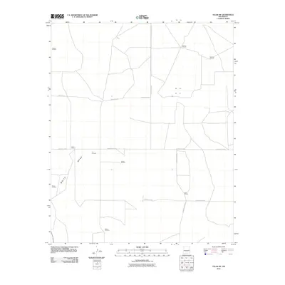
2010 Map of Tolar SW
USGS Topo · Published 2010About this map
White Mesa defines the western landscape of this Roosevelt County quadrangle, where the high plains terrain is marked primarily by scattered windmills and a geometric grid of rural roads. These points of interest, such as Leaning Windmill, Diamond Windmill, and Noblitt Windmill, serve as critical landmarks in an arid ranching environment where water sources dictated the placement of infrastructure. The presence of the Blanco Cemetery in the southwestern quadrant provides a specific point of reference for genealogists and local historians tracking early settlement patterns in this part of New Mexico. The road network, including N Roosevelt Road 3 and Roosevelt Road 5, illustrates the systematic organization of the territory into large agricultural and grazing blocks characteristic of the region's 21st-century rural character.
Find a feature on this map
16 named features on this map. Tap any name to fly to it.
Don’t see what you’re looking for? This feature index may not catch every label — zoom into the map to look around manually.
Map Details
Editions of this 2010 Tolar SW Map
This is the sole edition of this map. No revisions or reprints were ever made.
Other maps of this area

1954 · Fort Sumner
USGS Topo · 1:250,000

1954 · Clovis
USGS Topo · 1:250,000

1958 · Fort Sumner
USGS Topo · 1:250,000

1958 · Clovis
USGS Topo · 1:250,000
1967 · Watts Hill
USGS Topo · 1:24,000

1968 · Lomas Gatos
USGS Topo · 1:24,000

1968 · Taiban
USGS Topo · 1:24,000

1973 · Tolar
USGS Topo · 1:24,000

1973 · Krider
USGS Topo · 1:24,000
1973 · Gammil Well
USGS Topo · 1:24,000