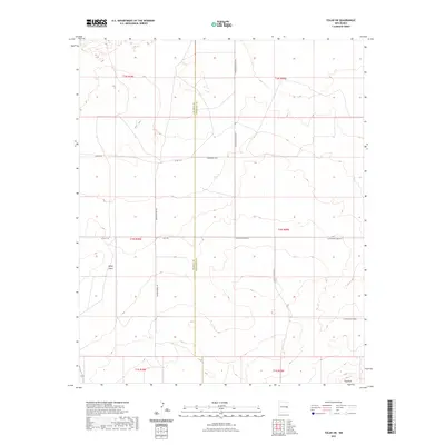
2023 Map of Tolar SW
USGS Topo · Published 2023About this map
The high plains of eastern New Mexico define this landscape along the De Baca Co Roosevelt Co boundary. The terrain is marked by distinct geological elevations such as White Mesa and The Mesa, which rise above the surrounding tablelands. This region is etched by a network of rural transport routes including Wagon Wheel Rd, Colt Rd, and various county roads like Co Rd 2-39 that follow the grid of the Public Land Survey System. The sparse settlement pattern and systematic road naming convention, including N Roosevelt Road Ba and N Roosevelt Road Az, reflect the organized ranching and agricultural expansion across the High Plains in the modern era.
Find a feature on this map
18 named features on this map. Tap any name to fly to it.
Don’t see what you’re looking for? This feature index may not catch every label — zoom into the map to look around manually.
Map Details
Editions of this 2023 Tolar SW Map
This is the sole edition of this map. No revisions or reprints were ever made.
Other maps of this area

1954 · Fort Sumner
USGS Topo · 1:250,000

1954 · Clovis
USGS Topo · 1:250,000

1958 · Fort Sumner
USGS Topo · 1:250,000

1958 · Clovis
USGS Topo · 1:250,000
1967 · Watts Hill
USGS Topo · 1:24,000

1968 · Lomas Gatos
USGS Topo · 1:24,000

1968 · Taiban
USGS Topo · 1:24,000

1973 · Tolar
USGS Topo · 1:24,000

1973 · Krider
USGS Topo · 1:24,000
1973 · Gammil Well
USGS Topo · 1:24,000