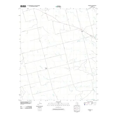
2010 Map of Tolbert
USGS Topo · Published 2010About this map
Farmers Valley and the small settlement of Tolbert anchor this North Texas agricultural landscape during the first decade of the 21st century. The terrain is defined by a dendritic network of seasonal drainages, including Wildcat Creek, Boggy Creek, and Dan Creek, which eventually reach the wide valley of the Pease River at the southern boundary. This area is heavily organized by a grid of rural roads such as Walton Rd and Boone Rd, interspersed with county routes that follow the section lines of the surrounding ranchland. Traces of local infrastructure appear in labels like Dump Ground Rd, while the passage of Elizabeth Creek through Farmers Valley highlights the relationship between small-scale ranching settlements and the essential water sources of the rolling plains.
Find a feature on this map
33 named features on this map. Tap any name to fly to it.
Don’t see what you’re looking for? This feature index may not catch every label — zoom into the map to look around manually.
Map Details
Editions of this 2010 Tolbert Map
This is the sole edition of this map. No revisions or reprints were ever made.
Other maps of this area

1955 · Lawton
USGS Topo · 1:250,000

1958 · Vernon
USGS Topo · 1:62,500

1958 · Medicine Mound
USGS Topo · 1:62,500

1958 · Elmer
USGS Topo · 1:62,500

1960 · Quanah
USGS Topo · 1:62,500

1983 · Warrior Hollow
USGS Topo · 1:24,000

1983 · Tolbert
USGS Topo · 1:24,000
1983 · Rayland
USGS Topo · 1:24,000
1983 · Lockett
USGS Topo · 1:24,000
1983 · Vernon
USGS Topo · 1:24,000