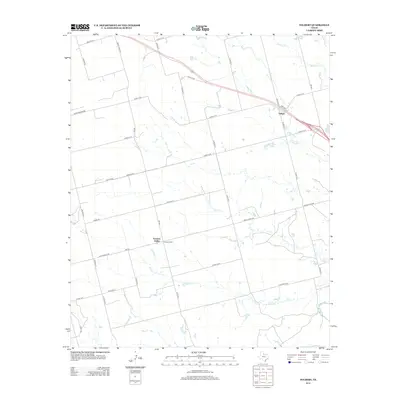
2012 Map of Tolbert
USGS Topo · Published 2012About this map
Tolbert and Farmers Valley anchor this agricultural landscape in Wilbarger County, where a network of county roads organizes the terrain into a sprawling grid. The drainage pattern of the region is defined by several seasonal waterways, including Wildcat Cr in the north and the winding course of Elizabeth Cr and Dan Cr to the south. These tributaries eventually feed toward the Pease River, which forms a significant natural boundary at the southeastern corner of the quadrangle. The map documents the persistent rural character of the area, traced through local landmarks like Walton Rd and Ranch Road 925. The infrastructure reflects a long-standing ranching and farming economy, with named routes like Butler Rd and Evans Rd providing access to isolated homesteads and parcels typical of the Texas Panhandle's eastern edge.
Find a feature on this map
35 named features on this map. Tap any name to fly to it.
Don’t see what you’re looking for? This feature index may not catch every label — zoom into the map to look around manually.
Map Details
Editions of this 2012 Tolbert Map
This is the sole edition of this map. No revisions or reprints were ever made.
Other maps of this area

1955 · Lawton
USGS Topo · 1:250,000

1958 · Vernon
USGS Topo · 1:62,500

1958 · Medicine Mound
USGS Topo · 1:62,500

1958 · Elmer
USGS Topo · 1:62,500

1960 · Quanah
USGS Topo · 1:62,500

1983 · Warrior Hollow
USGS Topo · 1:24,000

1983 · Tolbert
USGS Topo · 1:24,000
1983 · Rayland
USGS Topo · 1:24,000
1983 · Lockett
USGS Topo · 1:24,000
1983 · Vernon
USGS Topo · 1:24,000