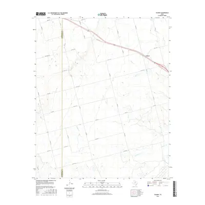
2016 Map of Tolbert
USGS Topo · Published 2016About this map
Tolbert serves as a central waypoint in this north Texas landscape, positioned where the high plains of the Panhandle begin to give way to the drainage of the Pease River. The terrain is defined by a series of south-trending watercourses, including Wildcat Cr, Boggy Cr, and Dan Cr, which carve subtle relief into the agricultural plains. This survey documents a sophisticated network of rural infrastructure, with numerous county roads such as Co RD 114 W and Co RD 110 W forming a rigid grid across the county line between Hardeman Co and Wilbarger Co. The proximity of Elizabeth Cr and the river at the southern boundary suggests a landscape shaped by seasonal water flow, where land use is dictated by the availability of drainage in an otherwise dry and open environment.
Find a feature on this map
36 named features on this map. Tap any name to fly to it.
Don’t see what you’re looking for? This feature index may not catch every label — zoom into the map to look around manually.
Map Details
Editions of this 2016 Tolbert Map
This is the sole edition of this map. No revisions or reprints were ever made.
Other maps of this area

1955 · Lawton
USGS Topo · 1:250,000

1958 · Vernon
USGS Topo · 1:62,500

1958 · Medicine Mound
USGS Topo · 1:62,500

1958 · Elmer
USGS Topo · 1:62,500

1960 · Quanah
USGS Topo · 1:62,500

1983 · Warrior Hollow
USGS Topo · 1:24,000

1983 · Tolbert
USGS Topo · 1:24,000
1983 · Rayland
USGS Topo · 1:24,000
1983 · Lockett
USGS Topo · 1:24,000
1983 · Vernon
USGS Topo · 1:24,000