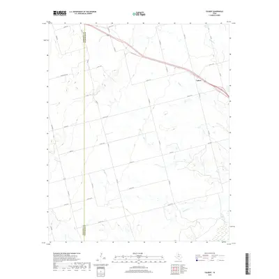
2019 Map of Tolbert
USGS Topo · Published 2019About this map
The settlement of Tolbert sits in the northeast corner of this Wilbarger County landscape, situated along a network of ranch-to-market roads and county routes. The terrain is defined by a series of south-flowing drainage systems, including Wildcat Cr, Boggy Cr, and Dan Cr, all of which eventually converge toward the Pease River in the southern reaches of the map. This area represents a classic section of the Texas rolling plains where the Hardeman Co-Wilbarger Co line divides the agricultural and grazing lands. The map shows a high density of rural infrastructure, from Dump Ground Rd to Elizabeth Cr, reflecting the managed landscape of North Texas. The presence of numerous numbered routes such as Fm 925 and Fm 432 highlights the transition from early local trails to a modernized transit network serving isolated farmsteads and rural properties.
Find a feature on this map
36 named features on this map. Tap any name to fly to it.
Don’t see what you’re looking for? This feature index may not catch every label — zoom into the map to look around manually.
Map Details
Editions of this 2019 Tolbert Map
This is the sole edition of this map. No revisions or reprints were ever made.
Other maps of this area

1955 · Lawton
USGS Topo · 1:250,000

1958 · Vernon
USGS Topo · 1:62,500

1958 · Medicine Mound
USGS Topo · 1:62,500

1958 · Elmer
USGS Topo · 1:62,500

1960 · Quanah
USGS Topo · 1:62,500

1983 · Warrior Hollow
USGS Topo · 1:24,000

1983 · Tolbert
USGS Topo · 1:24,000
1983 · Rayland
USGS Topo · 1:24,000
1983 · Lockett
USGS Topo · 1:24,000
1983 · Vernon
USGS Topo · 1:24,000