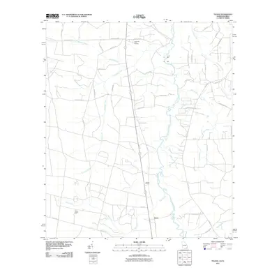
2011 Map of Toledo
USGS Topo · Published 2011About this map
The Saint Marys River carves a winding path along the border of Charlton County, Georgia, and Florida, anchoring a landscape defined by its blackwater tributaries and rural creek-side settlements. Near the center of this 2011 survey, the Toledo community sits at a crossroads, its presence marked by the Toledo Lookout Tower and nearby Johnson Cemetery. The terrain is drained by an extensive network of waterways, including the prominent Cornhouse Creek, which lends its name to the Cornhouse Creek Cemetery in the northern portion of the quadrangle. A dense grid of local timber and county roads, such as Chesser Island Rd and Kings Rd, connects scattered residences and family landmarks like the Mulberry Landing Anx, reflecting a long-standing reliance on the river and its adjacent wetlands for both transport and livelihood.
Find a feature on this map
45 named features on this map. Tap any name to fly to it.
Don’t see what you’re looking for? This feature index may not catch every label — zoom into the map to look around manually.
Map Details
Editions of this 2011 Toledo Map
This is the sole edition of this map. No revisions or reprints were ever made.
Other maps of this area

1917 · Boulogne
USGS Topo · 1:62,500

1917 · Hilliard
USGS Topo · 1:62,500

1918 · Folkston
USGS Topo · 1:62,500

1918 · Moniac
USGS Topo · 1:62,500

1919 · Hilliard
USGS Topo · 1:62,500

1919 · Boulogne
USGS Topo · 1:62,500

1942 · Moniac
USGS Topo · 1:62,500

1948 · Jacksonville
USGS Topo · 1:250,000

1954 · Valdosta
USGS Topo · 1:250,000

1957 · Jacksonville
USGS Topo · 1:250,000