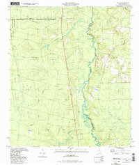
1994 Map of Toledo
USGS Topo · Published 1998About this map
The St Marys River winds along the Georgia-Florida border in this coastal plain survey, serving as the primary geographic divide between Charlton and Nassau counties. To the west, the landscape is defined by the eastern margins of the Okefenokee National Wildlife Refuge, where the Suwannee Canal and Ridge Trail mark the transition into the swamp. The small settlement of Toledo sits near the riverbanks, anchored by the Toledo Lookout Tower and the nearby Johnson Cem. The hydrology is particularly dense, with numerous tributaries like Cornhouse Creek and Harris Creek feeding into the main river system. This map captures a rural landscape dominated by timber management and wetland conservation, providing a clear view of the access points to Chesser Island via the Chesser Island Road.
Find a feature on this map
19 named features on this map. Tap any name to fly to it.
Don’t see what you’re looking for? This feature index may not catch every label — zoom into the map to look around manually.
Map Details
Editions of this 1994 Toledo Map
This is the sole edition of this map. No revisions or reprints were ever made.
Other maps of this area

1917 · Boulogne
USGS Topo · 1:62,500

1917 · Hilliard
USGS Topo · 1:62,500

1918 · Folkston
USGS Topo · 1:62,500

1918 · Moniac
USGS Topo · 1:62,500

1919 · Hilliard
USGS Topo · 1:62,500

1919 · Boulogne
USGS Topo · 1:62,500

1942 · Moniac
USGS Topo · 1:62,500

1948 · Jacksonville
USGS Topo · 1:250,000

1954 · Valdosta
USGS Topo · 1:250,000

1957 · Jacksonville
USGS Topo · 1:250,000